Reading and Interpreting Maps
Key IdeasAll maps must have a compass rose.
A Compass Rose shows direction. It looks like a cross. Not all compasses have N,E,S,W on them. Some may have just North labeled as N. All maps should have a scale. A Scale shows the distance on a map. For example, 1 inch on a map may represent 50 miles. Look at the scale to determine the actual distance between sites on the map. Pay attention to the measuring unit. Some scales will show miles, some will show a distance in kilometers, some will show distance in feet. All maps need a key. Maps have different symbols on them. Boundaries may be a dashed line. Rivers might be a blue line. Cities might be shown with a star. Look at the key to know what each of these symbols mean. Maps should also have a title that shows the viewer what they are looking at. 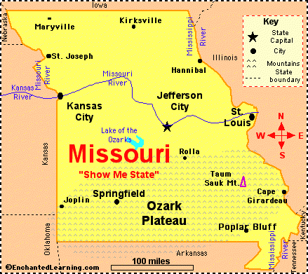
|
|
